

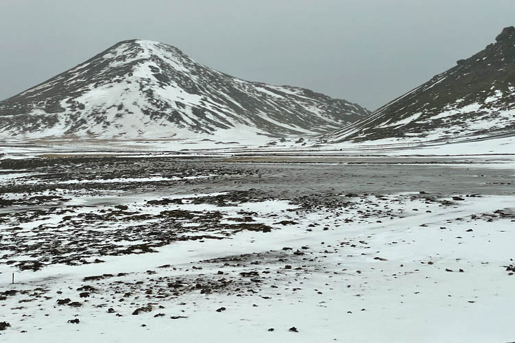
This volcanic eruption began on March 19, 2021 as a fissure eruption in Geldingadalir, south of Fagradalsfjall near Grindavik, Reykjanes Peninsula.
Fagradalsfjall volcano was "sleeping" for 6000 years. The last known volcanic activity on Reykjanes Peninsula is 800 years ago.
The eruption was preceded by a swarm of earthquakes beginning in December 2020 through March 2021.
Because of those earthquakes were thought to be triggered by dyke intrusions and magma movements under the peninsula it was a clear warning sign for an impending eruption.
The name "Fagradalsfjall" is a compound of the Icelandic words "fagur" (fair, beautiful), "dalur" (dale, valley) and "fjall" (fell, mountain).
"Geldingadalir" can be roughly translated as "invertile valley".
Source: Wikipedia
(Click here to read more)
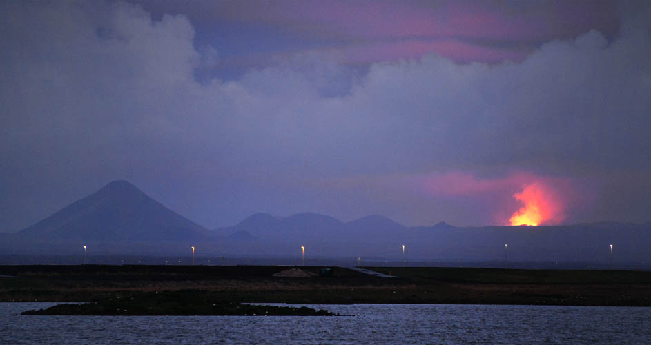
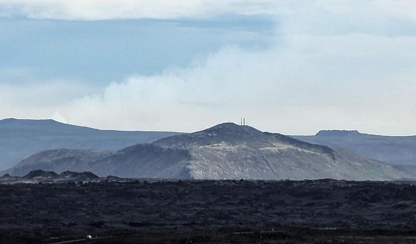
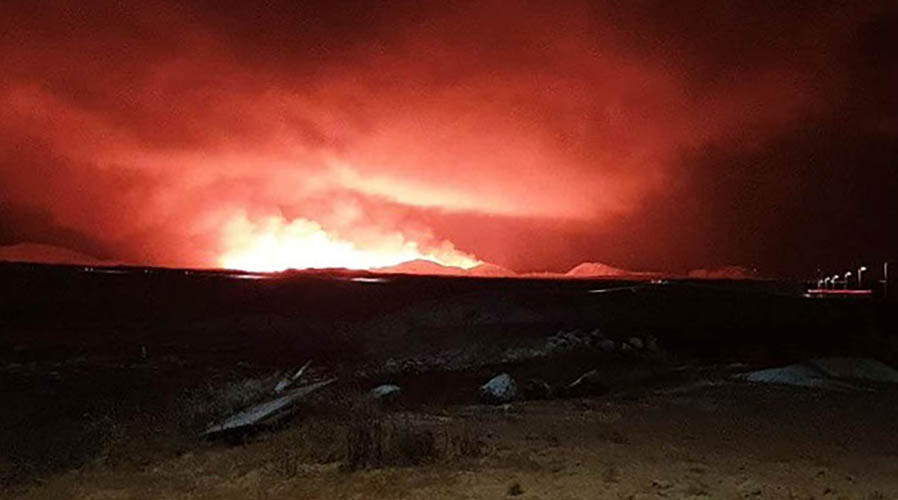
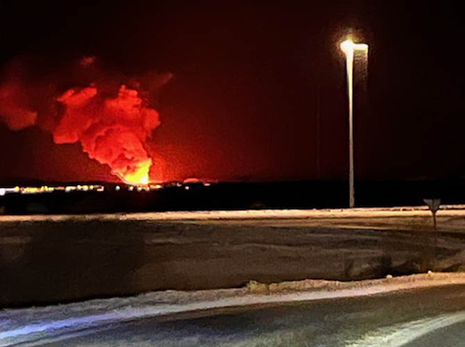
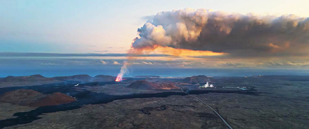
My first photos of the eruption are taken during a short (legal) walk at night from my 5-days Covid-19 quarantine location in Álftanes.
It's Tuesday, June 1st, 2021 about 01:15 a.m. (local icelandic time) and the straight line distance to the eruption site is 27 km.
After decreasing lava flow during the last days the intensity suddenly increased again since last night.
The eruption can be seen very clearly. Even the clouds are illuminated.
The volcano is behaving like a geysir: it is erupting approx. every ten minutes.
Currently the hiking paths will be changed by the authorities, because the closest viewpoint is about to be surrounded by lava. In that case rescue work would only be possible by helicopter and in good weather conditions. That's too risky.
Hopefully more photos will follow from Friday, June 4th, 2021 when I'm "free" to go there after my quarantine.
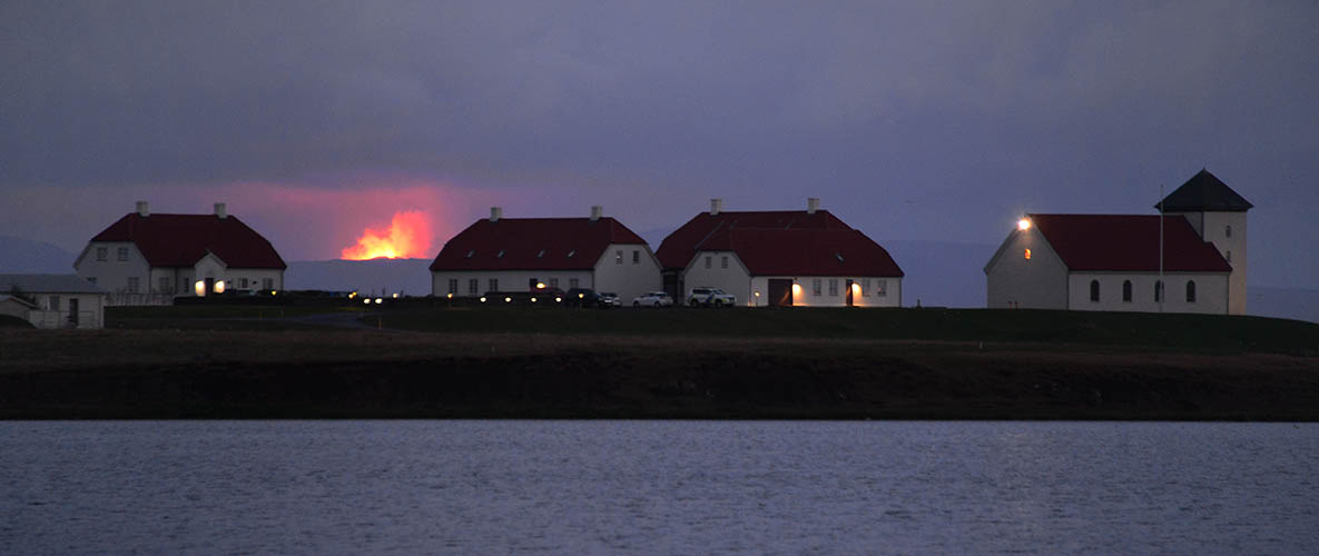
Geldingadalir / Fagradalsfjall eruption in the background of Bessastaðir (the icelandic president's residence)
Mount Keilir (378 m / visible hight above ground 199 m) on the left with volcano's glow on the right
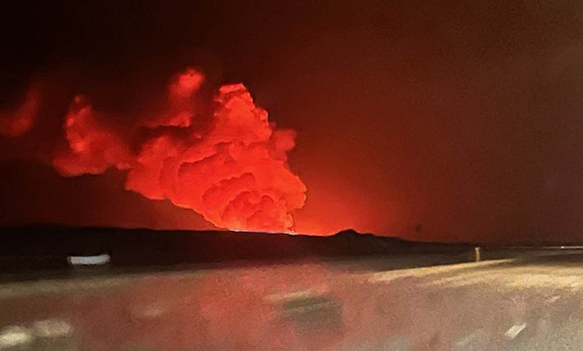
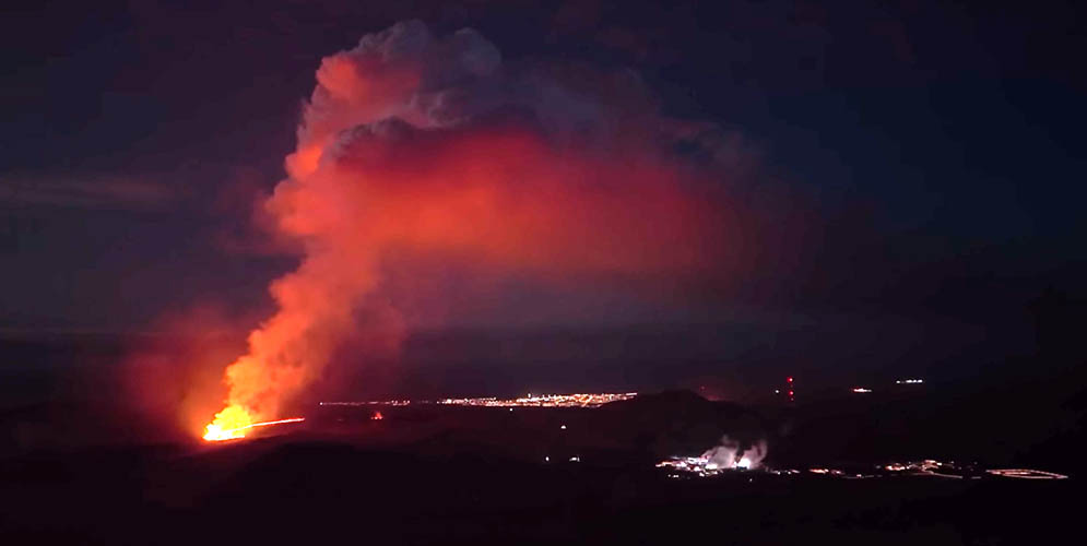
It's still Tuesday, June 1st, 2021 but now in the late evening at 11:15 p.m. just before sunset in Iceland.
Still in quarantine I wonder if I can see the eruption from my distant position even at the last direct sunlight of the day.
I go out for my next (legal) short walk along the beach and guess what happens... The eruption pops up right behind the mountains and can be seen very clearly again!
From my position the straight line distance to the eruption site is now about 25 km.
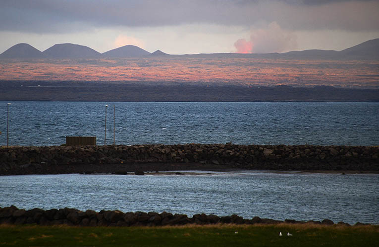
Eruption seen from Álftanes / Garðabær with Reykjanes Peninsula in horizontal sunlight
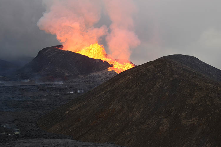
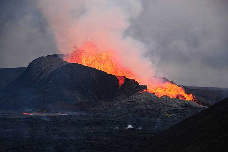
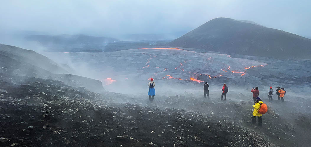
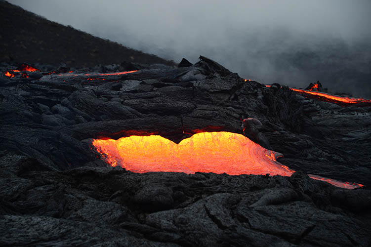
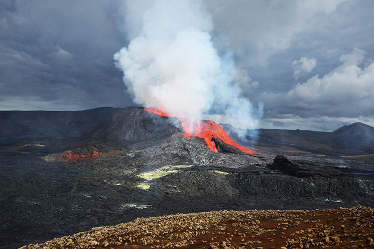
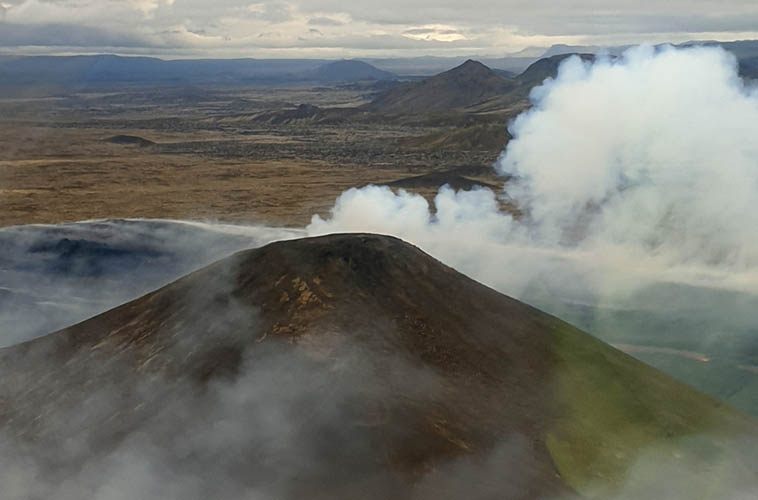
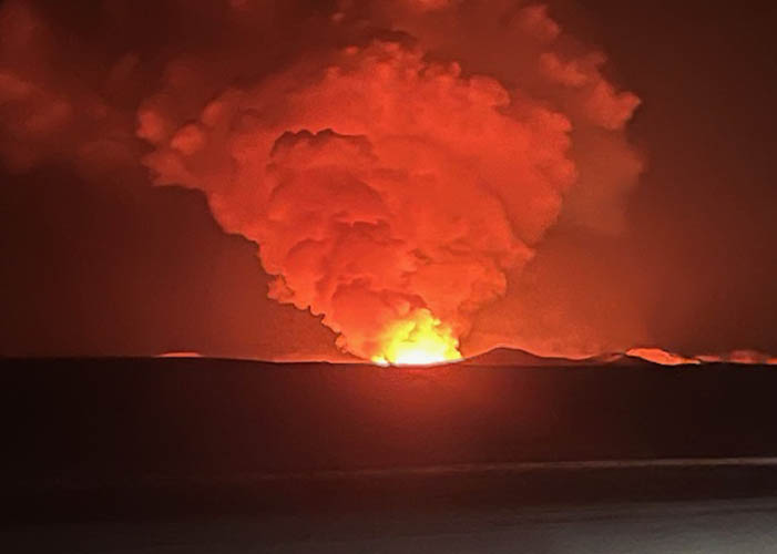
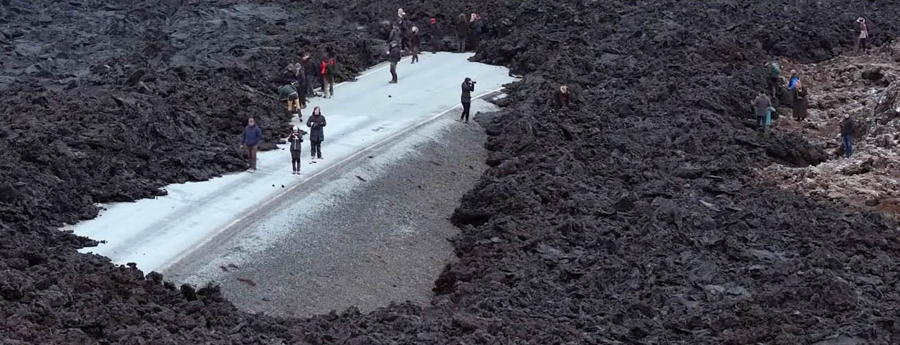
Today's Friday, June 4th, 2021, 01:00 p.m. and I am free from quarantine! Short preparation and off we go towards Fagradalsfall.
At 03:00 p.m. I leave the car at the parking lot 10 min. from Grindavík. Best weather for a walk to the volcano: rain und fog!
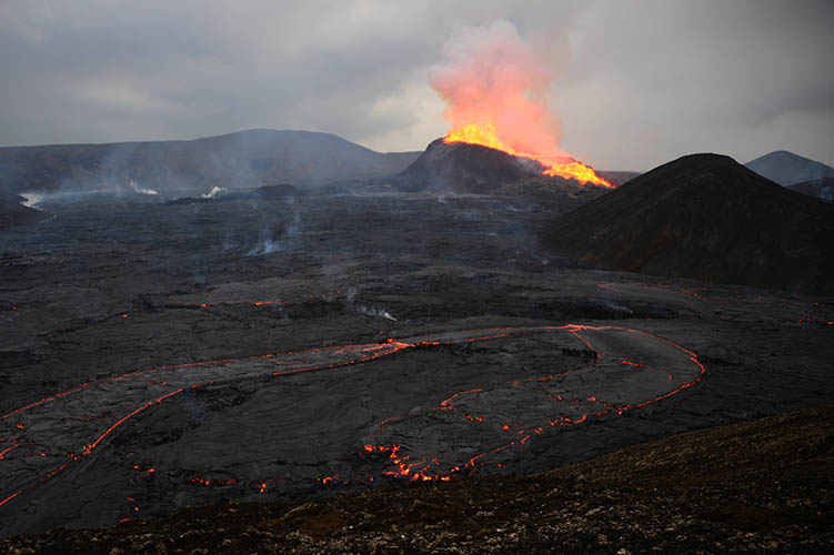
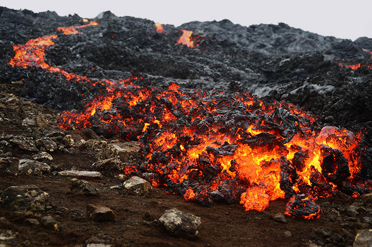
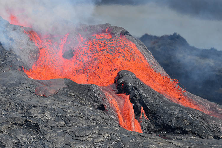
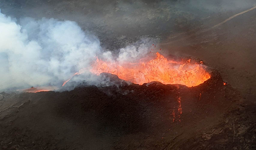
After a 45 min. walk I arrive at the current viewpoint unfortunately in densest fog. You can hardly go to the "lava river" in the valley. But what now happens is unbelievable: suddenly the fog disappears, rain stops and the crater ist clearly visible!
The whole valley is full of boiling lava under a thin grey surface with glowing cracks and the air is tremendously hot. The lava is slowly but unstoppable pouring down the valley. Every ten minutes you hear the crater deeply rumbling and blow out a fountain!
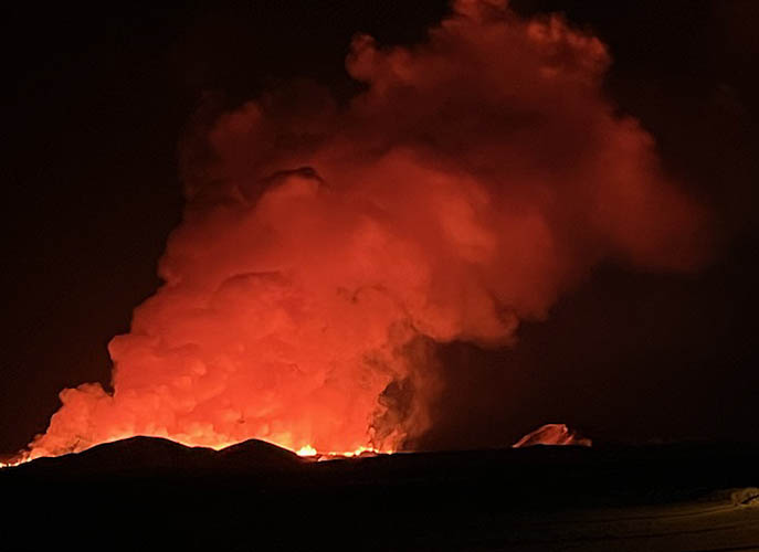
Please enjoy my first pictures from the eruption site... (more pictures will follow)
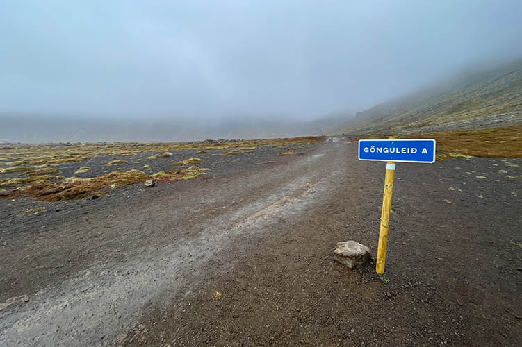
Hiking trail to the eruption site
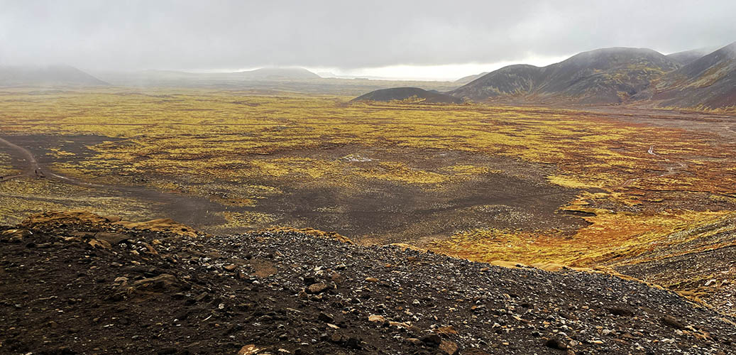
Almost half way to the volcano / Nátthagikriki
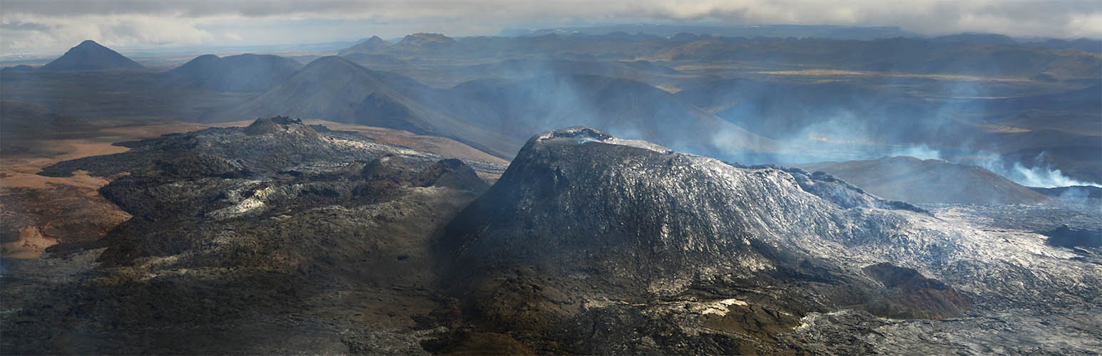
Geldingadalir / Fagradalsfjall
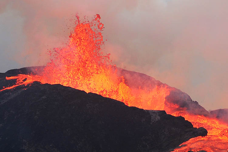
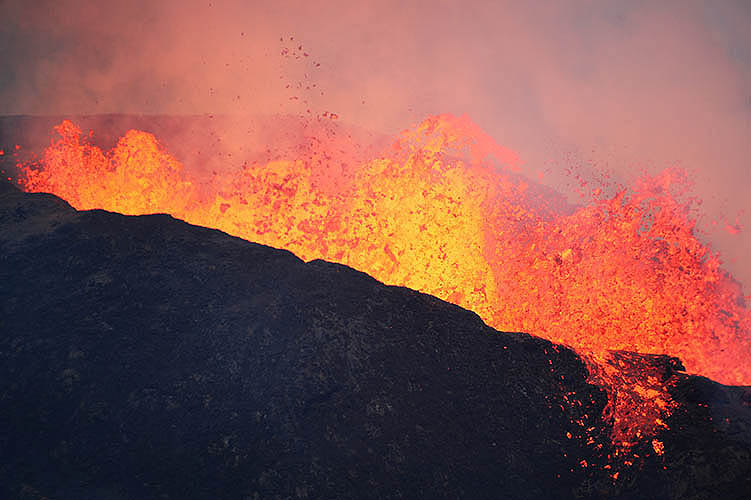
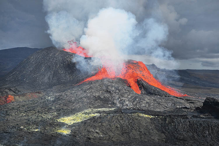
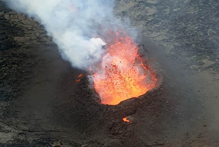
Currently the eruptions appear approx. every 10 minutes and last about 2-3 minutes
Suddenly the lava surface in Geldingadalir lifts about one meter and changes into a lighter grey...
A kind of lava flood wave begins to flow towards the transition to Nátthagi valley...
...but stops just before crossing the saddle
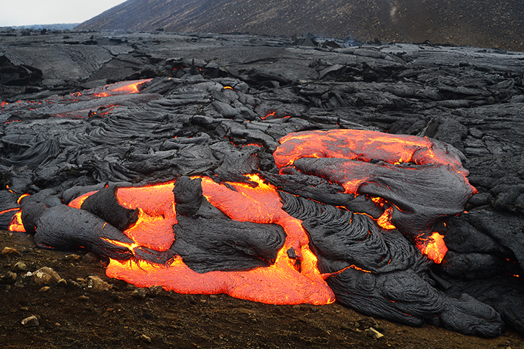
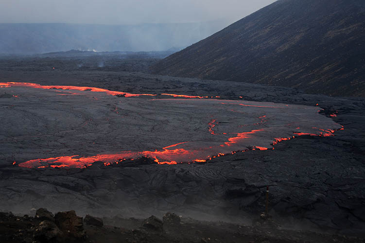
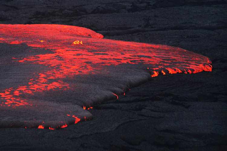
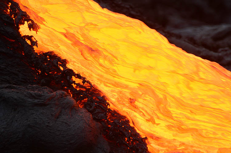
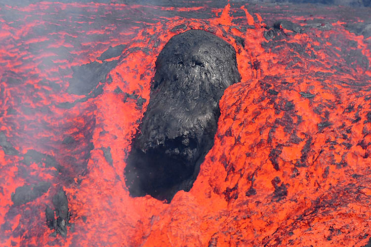
Lava pours into Nátthagi valley forming various shapes and streams
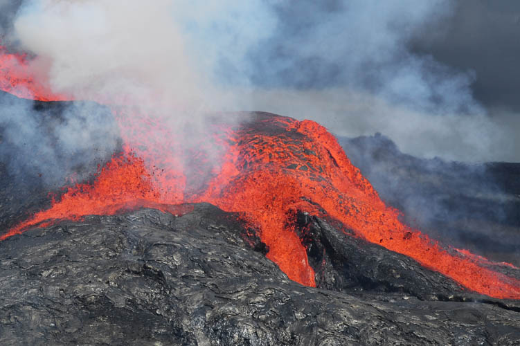
The air near the lava stream is tremendously hot
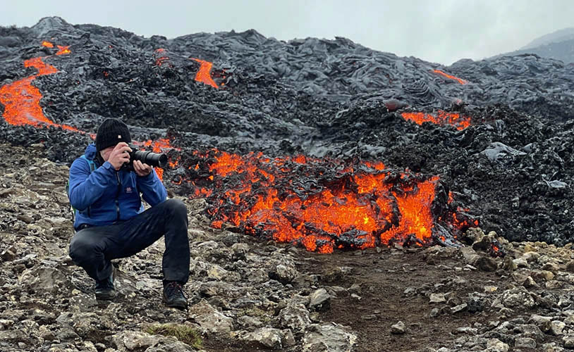
That close to the lava you can only stay for about 60 seconds
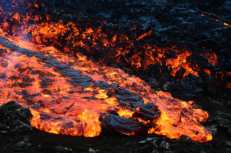
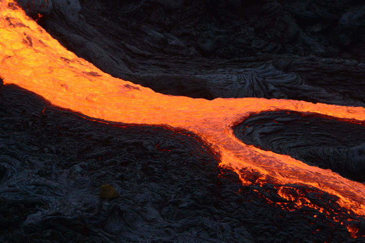
Slow moving lava stream
Fast moving lava stream
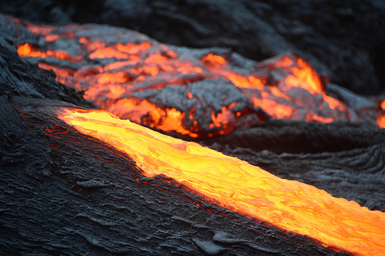
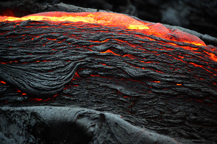
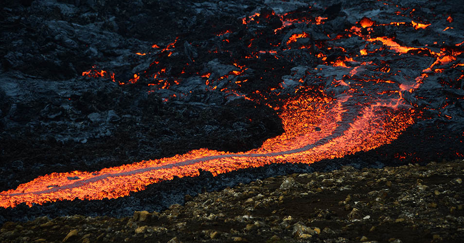
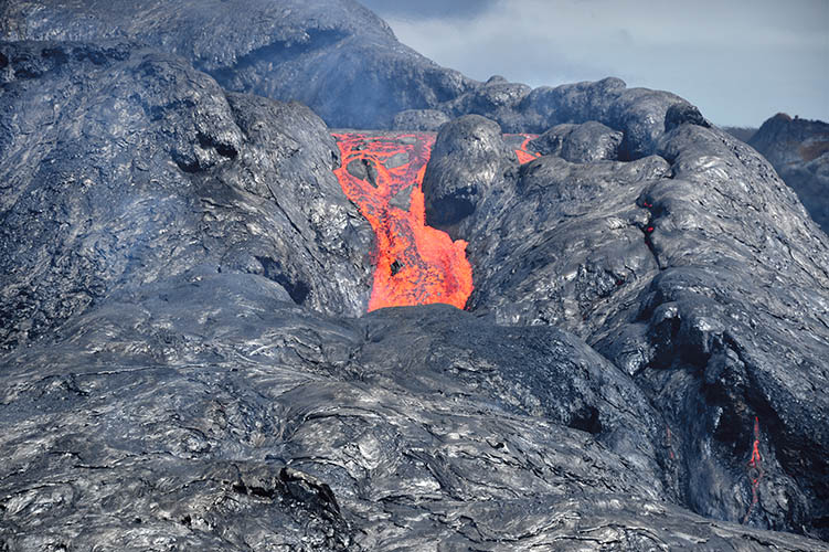
Slow moving lava stream pouring down to Nátthagi valley
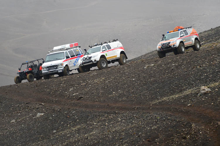
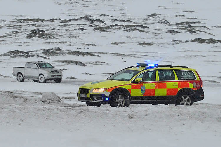
Björgunarsveit (Rescue Team) above Nátthagi valley
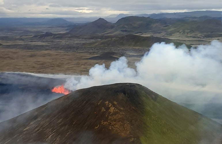
Monday, June 7th, 2021, 11:30 a.m.
The lava output was clearly increasing the last days. Geologists consider it as possible, that the eruption could last for years - we will see.
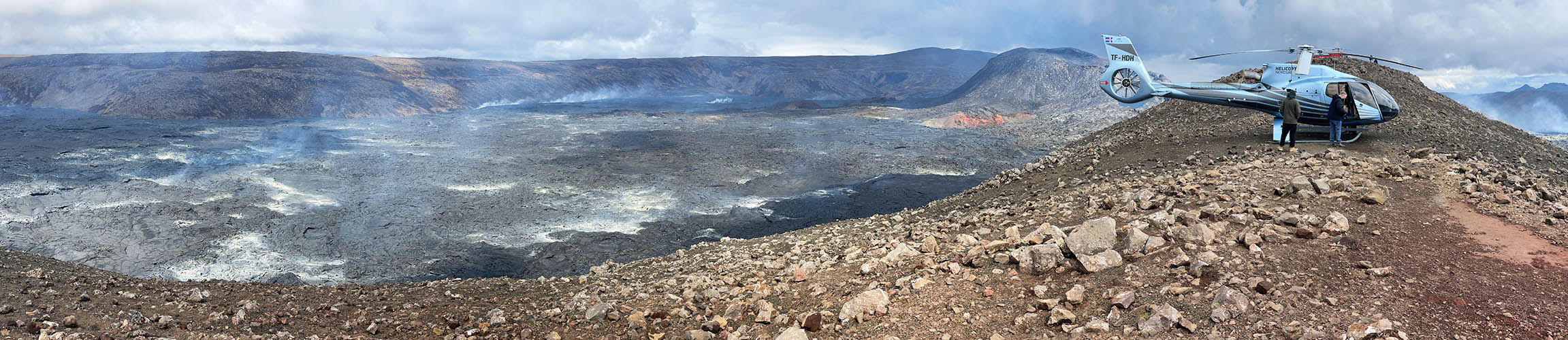
Meanwhile, lava flows down the two valleys towards the coast. The scenery changes every day. Before I arrived first time at the site you could get very close to the crater on a hill. You can see that hill right in front of the crater in my last pictures.
That hill is now completely surrounded by lava and there is only one chance left to get there...
...by HELICOPTER!!!
So I signed up for a place on the waiting list at Norðurflug Helicopter Company and was actually lucky to get one!
Please see the results from this tour...
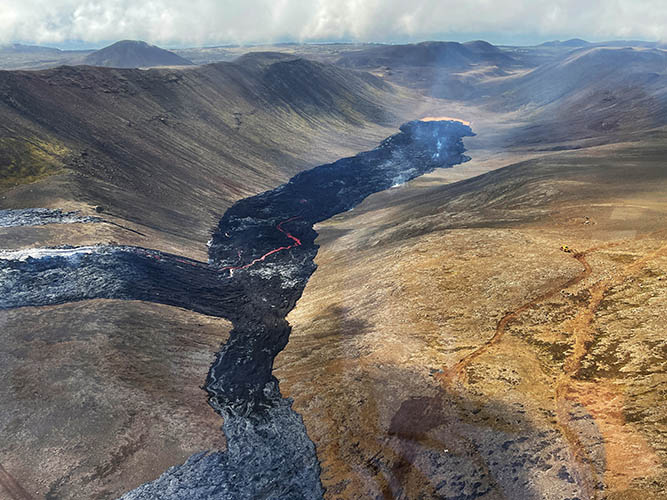
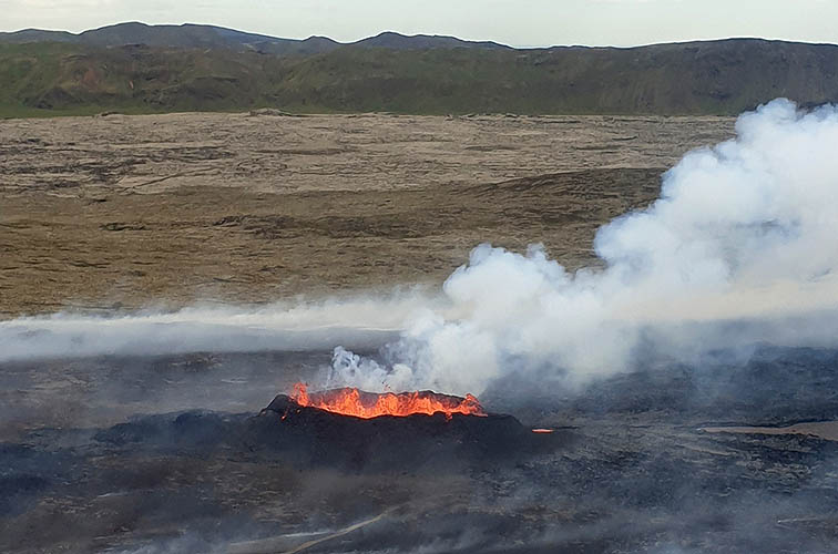
Nátthagi valley
Former visitor hill enclosed by lava (with Geldingadalir to the left and Meradalir to the right)
Geldingadalir / Fagradalsfjall seen from top of former visitor hill
PLEASE PRESS PLAY-BUTTON
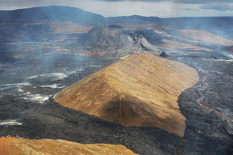
View to the west - Geldingadalir with Fagradalsfjall to the left behind the crater
View to the east - Meradalir to the left with transition to Nátthagi valley to the right
Small inactive craters to the left of the large active one in the middle
In the beginning the event was called the "Fagradalsfjall Eruption".
Over the past few days the term "Geldingadalir volcano" has been used more and more.
In fact Fagradalsfjall is the mountain to the west of the crater. The crater itself is located in the Geldingadalir.
Yet the new volcano does not have a final official name. (June 11th, 2021)
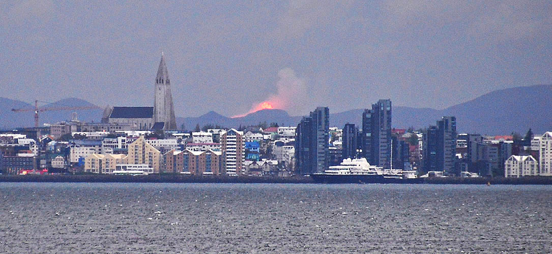
Sjáumst fljótt! (See you soon!) - Photo taken at night 10 km north of Reykjavík near Grundarhverfi / distance to the volcano 45 km
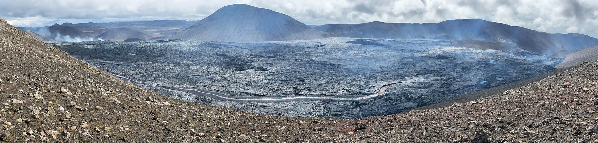
July 2021 - Currently volcano's behaviour varies day by day. Sometimes the fountain eruptions change to a continuous lava flow, sometimes lava stops completely and appears again the next day. It poors into Meradalir and down to Nátthagi valley but did not reach the coast yet. Due to volcanologists a prediction of volcano's behaviour is currently not possible. All in all, it currently looks like activity is weakening.
Officially confirmed by the authorities the lavafield's name is now...
That means "beautiful valley lava". This name was chosen by government from 340 proposals coming from Iceland's population.
That's it for now - We hope to be there again in early 2022 to see what's up at the eruption site.
Thursday, December 2nd, 2021.
Today the national police commissioner together with the Suðurnes police chief declared the end of the "uncertainty phase" for the Reykjanes Peninsula.
The end of the uncertainty phase is not to be equated with the official end of the eruption.
An icelandic rule states, that an eruption is only considered to have ended if no pouring lava has been detectable for three months.
Fagradalsfjall eruption began on March 19, 2021 and pouring lava was last to be observed on September 17th.
For this reason, the official end of the eruption will probably be declared shortly before christmas 2021 if nothing changes by then.
Thursday, December 18, 2021.
The Icelandic Met Office has declared the Fagradalsfjall eruption as over.
Wednesday, December 22, 2021.
Four days after declaring the eruption as over, seismic activities are suddenly increasing again.
As concequence of this "behavoir" the aviation code for the Reykjanes Peninsula has been switched to orange again.
The characteristics of the new earthquakes are similar to those in the weeks before the first eruption in March 2021.
This does not mean, that the eruption is certain to continue, but the chances do increase again.

Friday, February 18, 2022.
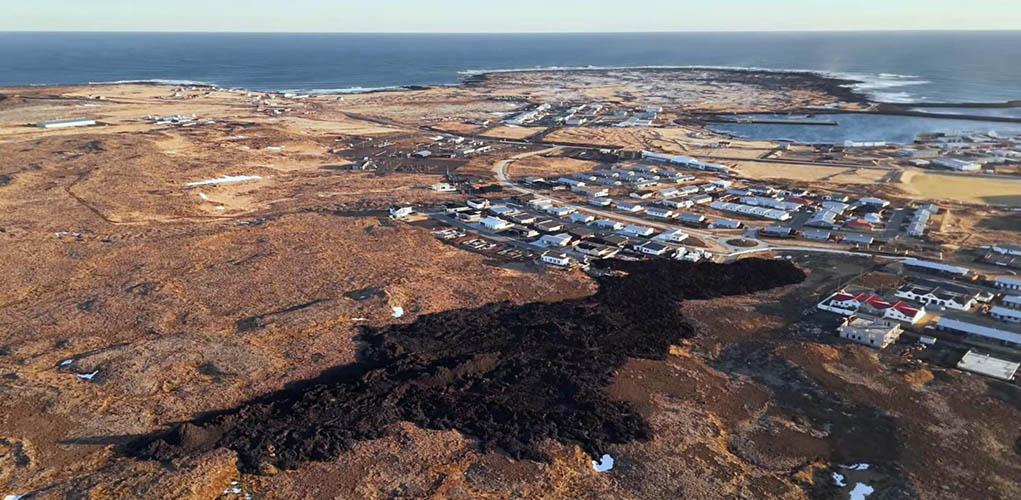
While approaching Iceland by plane today we have a clear view over the Reykjanes Peninsula. The spread of lava can be clearly seen in the snowy landscape.
Due to orange and red weather alert on Monday 21st and Tuesday 22nd we can not manage to walk again to the eruption site.
While being diverted via Grindavik on our way from the south towards Reykjavik (Hellisheiði is closed) we pass the completely empty parking lot in Geldingadalir. Thank goodness apparently nobody is stupid enough to walk to the eruption area in these extreme weather conditions.
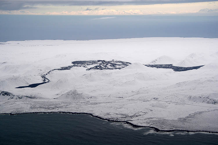
View over Fagradalsfjall eruption site at Reykjanes Peninsula
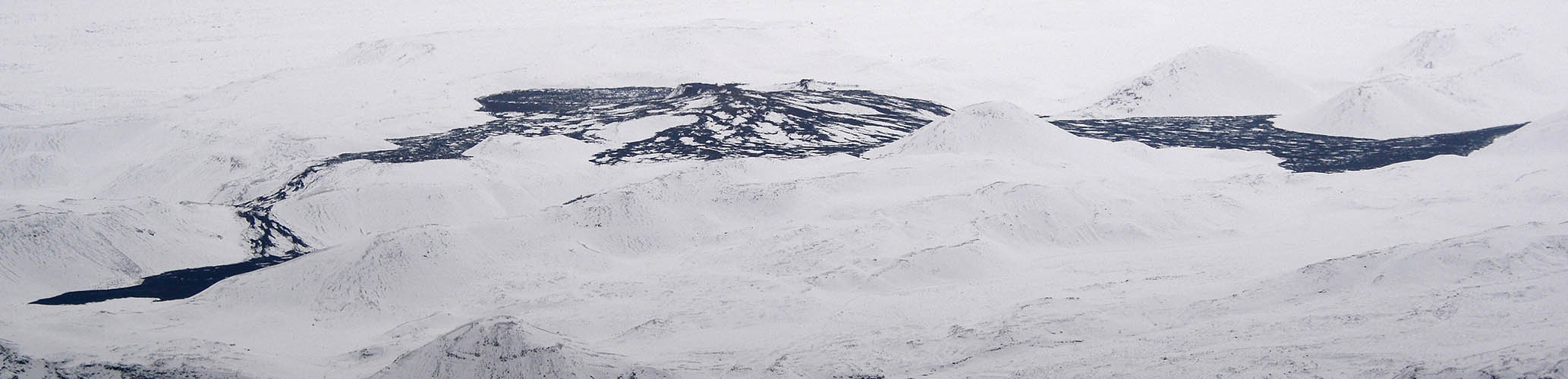
From left to right: Nátthagi valley, Geldingadalir, Fagradalsfjall, Meradalir
Empty parking lot at Geldingadalir
Lögreglan (Police) monitoring closed roads near Þorlákshöfn
Wednesday, August 3rd, 2022.
Fagradalsfjall is active again! Anounced by strong earthquakes, ground deformations and moss fires, magma has now reached the surface in Meradalir.
Currently the fissure is 100-150 m long and located in the western part of Meradalir. It produces a lava curtain with fountains several tens of meters high. A relatively huge amount of lava begins to flow down the valley.
Though authorities are currently recommending not to walk to the new eruption site, a few hikers are already there to watch the event. Volcanic gas emissions are very high and unpredictable at this early stage. If you go to the eruption site anyway, it is important to be aware of the wind direction and not to get too close.
We will try to get there from August 20th. Hopefully our plan will work...
Saturday, August 20, 2022.
While we are still on our way from northern Iceland to the south-west in our Jeep (please see MUNICH-ICELAND), our daughter fortunately manages to takes a picture of the eruption site while she approaches Iceland by plane.
The overview shows Geldingadalir with the white colored 2021 crater to the left and Meradalir with the smoke of the new crater near the picture's center.
You can also see the spread of lava in Nátthagi valley and it's remaining distance to the cost line.
In the background to the right Mount Keilir, Straumsvík Aluminium Smelter near Hafnarfjörður and even Reykjavík with the Hallgrímskirkja clearly appear.
And if you look really closely, you can even spot Bessastaðir (Residence of the Icelandic president) in the background's center.
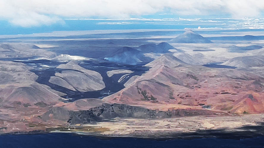
Eruption site with Mount Keilir, Straumsvík and Reykjavík in the background to the right
Monday, August 22, 2022.
Just in time at our first chance to get to the new eruption site, the volcano has decided to rest.
The last activities could be seen yesterday. Only the edge of the crater glowed a little during the night.
Currently nobody can predict whether the eruption is just resting or has ended.
In any case, significant seismic activity is still measurable. So there is still the chance, that it will continue in the near future.
We will see...!
Tuesday, August 30, 2022.
Today the second Fagradalsfjall eruption is officially declared as over.

Monday, July 10, 2023.
The third eruption-phase at Reykjanes Peninsula just started today at 04:20 pm local time with a 200 meter long eruption fissure.
It is located at "Litli Hrútur" about 3 km south-west of Mt. Keilir. Currently it does not appear that villages or infrastructure are threatened.
Since we have been in Iceland last a few weeks ago, we are not there at the moment.
Wednesday, July 12, 2023.
In the meantime the eruption fissure is about one kilometer long and the first craters are forming along the fissure.
Overall the eruption has subsided significantly. However, there are still clearly visible fountains and lava is flowing.
Compared to both former eruptions the ammount of smoke appears very high.
Since today the eruption site has been officially opened for visitors by the authorities.
The only "legal" hiking path to the fissure starts again east of Grindavík at the parking lot. It is about 9 km long in one direction.
Good equipment and sufficient physical condition is strongly recommended!
The new lava field has already been given a name: it is called "Driffellshraun".
Thursday, July 13, 2023.
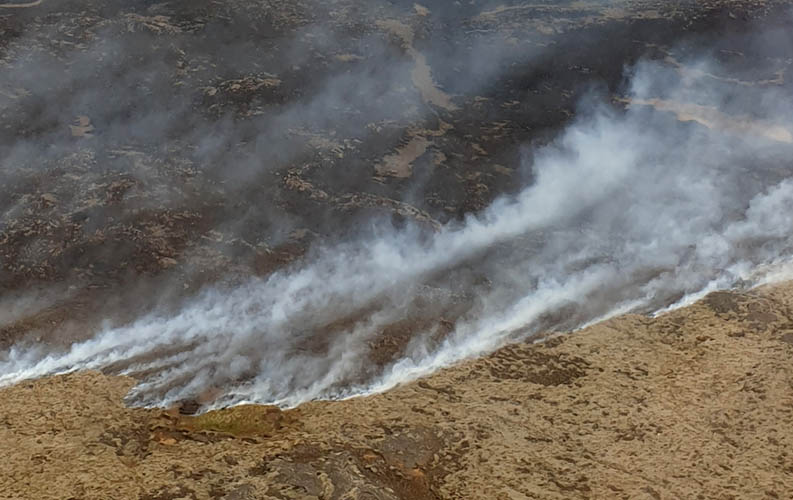
From today on, access to the eruption site is forbitten until further notice. The authotities have closed the hiking path to Litli Hrútur and the area around the fissure incl. Mt. Keilir.
The reason for this decision is the heavy smoke development caused by moss fires. It is a huge risk for visitor's health.
Normally those moss fires are reduced by rain and wet ground. But since the weather has been nice and sunny for days now, the fires are not being contained naturally. Even the fire brigade is now fighting wildfires around the eruption site.
However, we wouldn't be the "Huh!-Team" if we couldn't still manage to take great photos from the eruption for documentation! Now it's time to introduce two new "Huh!-Photographer": Silvia Schweizer (from Switzerland) and Matthias Rößner (from Germany).
Matthias is approaching the parking lot at the beginning of the hiking trail and discovers, that the area has been closed. Police is telling visitors not to access the area.
So Matthias sent us pictures from the distance showing smoke spread over the landscape. Currently the smoke is blown to the open sea and doesen't effect Reykjanes Peninsula or even the capital area.
Please see the following pictures...
Faintly visible smoke over the landscape being blown to the south (Picture taken from Road 427)

Smoke behind the hills seen from trailhead at closed hiking path
Plume of smoke with Mt. Þorbjörn in the foreground (Picture taken from Road 425)

Friday, July 14, 2023.
Our Friend Dominik Weil from Villa Fjordblick and Villa Künstlerblick gives a fast call to Silvia, who's currently in one of his houses at Hvalfjörður. He tells her about flights across the eruption site.
After the call with Dominik, Silvia spontaneously "jumps" into a helicopter from "Norðurflug" in Reykjavík and manages to get real impressive aerial photos out of the helicopter's window!
Enjoy the impressions...
Since Matthias will be in Iceland a little longer with his Volkswagen T4 syncro, he might try to walk to the volcano once the area is open again. We will see...
Thank's for now to Silvia and Matthias for providing the photos!
Funny fact: the two don't even know each other!
Approaching "Litli Hrútur" by helicopter
The 2023 eruption site appears behind the hill
Only this active crater is left at the 1 kilometer long fissure
Lava fountains are currently rather small
Crater's diameter is approx. 25 meters
Moss fires at the dry ground cause a lot of smoke
Monday, July 17, 2023.
The eruption site is partly opened again by the authorities but a clearly definded security zone is still closed.
Currently you can only get about 1 km close to the active crater and fresh lava.
Hikers who are caught inside the security zone are removed and even be fined by mountain guides and police.
It is only because of the misbehavior of a few unteachable visitors that such drastic measures need to be taken...
Thursday, July 20, 2023.
Yesterday a part of the crater wall collapsed, what is not an unusual occurrence at this stage of crater formation.
The interesting fact is, however, that the direction of the lava flow has changed from north to south as a result of the wall collapse.
If the lava flow keeps this intensity, it would reach the coastal road "Suðurstrandavegur" in about one month.
This statement is based on the calculation of Iceland's oldest technical consulting company "Verkís".
The situation remains exciting...
Sunday, August 6, 2023.
...and then everything turns out differently than expected:
After constantly decreasing lava output and finally no more visible pouring lave at the surface, the third eruption phase is declared as over by the icelandic volcanologist Þorvaldur Þórðarson.
If new volcanic activity starts from now on, it will be defined as a new eruption on the Reykjanes Peninsula.
Apart from Reykjanes currently a lot of vulcanos in Iceland are "rumbling".
There's strong seismic activity aroud the following vulcanos: Askja (incl. ground elevation), Katla or Grímsvötn and Hekla. Even below Torfajökull close to Landmannalaugar strong earthquakes occured.
Due to Þorvaldur Þórðarson an eruption like this would not be a "touristic eruption" like on Reykjanes. It could be more like the Eyjafjallajökull eruption in 2010 and possibly cause meltwater floods (Glacier run / Jökulhlaup), threaten the population or also hinder air traffic with ash clouds.
Let's see what happens next...

Thursday, November 2nd, 2023.
Since the third eruption-phase on the Reykjanes peninsula in July/August, the earthquake activity has never completely stopped. There have been several swarms of quakes with different epicenters.
But since a few days now, seismic activity has been increasing and concentrated in a place where you wouldn't necessarily want an eruption.
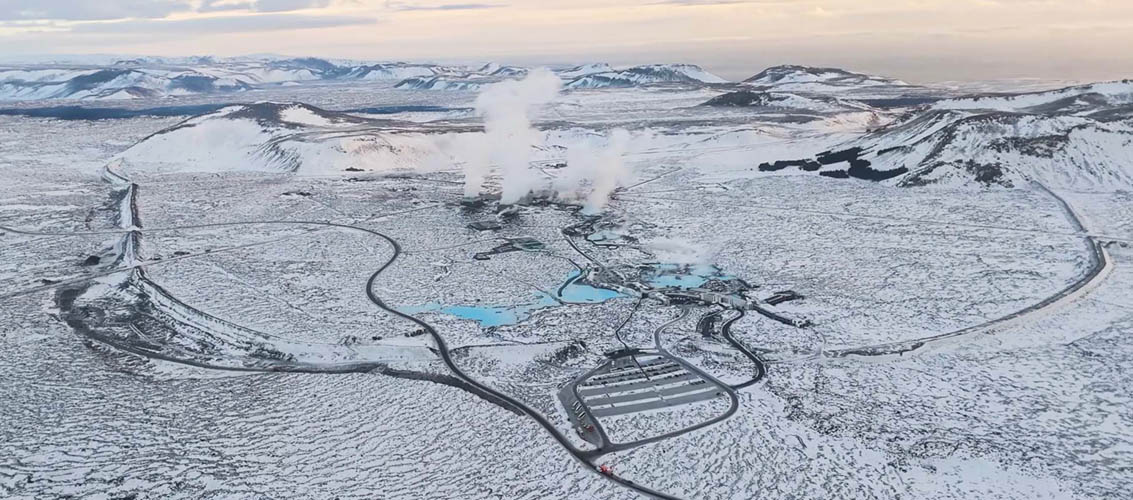
During the last 12 days a very fast 5-6 cm ground inflation occures at Svartsengi and magma is detected in a depth of about 4 kilometers. Svartsengi ist the area north west of Mt. Þorbjörn directly next to the famous Blue Lagoon and the Svartsengi power plant.
An eruption at this location would threaten both: the tourist hotspot Blue Lagoon and the geothermal power plant. The Svartsengi power plant provides the whole Reykjanes peninsula with electric energy and Grindavík additionally with hot water for heating the houses.
Even though the ground has infleated there and magma is accumulating at this point, this does not necessarily mean, that the eruption has to take place exactly there.
The magma can take a completely different path through the earth crust and the eruption takes place at a different location, even kilometers away.
Yesterday a strong seismic activity started and lasted for two hours. Normally this is a sign of a volcanic intrusion. But it is still no proof for an upcoming eruption at this location. It's even possible that everything calms down and no magma reaches the surface.
Now we hope that everything goes well and that it will be another “tourist eruption” like the three before and not one, that threatens people or infrastructure!
We will continue to report...
Tuesday, November 7, 2023.
Although earthquake activity has decreased significantly in recent days, land uplift continues.
The Icelandic Meteorology Office estimates, that the shape of magma intrusions around Mt. Þorbjörn is possibly different from those at Fagradalsfjall in the last years: At Fagradalsfjall there were more or less vertical intrusions comparing to intrusions in horizontally ledges in the current situation. These horizontal structures are only about 1 meter thick but can spread very wide without bringing magma to the surface.
The current volume of magma in about 4 km depth is estimated about six million cubic metres. Calculations show that this amount of magma is twice as large as in the previous three eruptions. The possible lava flow is predicted to be 7m³/s - four times higher than during the last three episodes.
However, it is still not certain that an eruption will actually take place! If it happens anyway, it is still most likely to be west of the power plant and the Blue Lagoon, maybe directly at the crater row of "Illahraunsgígar" from the 13th century eruption. Appropriately "Illahraunsgígar" translated in english means "Evil Lava Craters".
In any case, evacuation plans for the Blue Lagoon, the power plant and Grindavík have been developed in the recent days by the authorities and were presented to the public yesterday.
Grindavík is not expected to be threatened by lava, but houses would no longer be able to be heated if hot water and electricity supply from the geothermal power plant would stop.
As a precautionary measure, emergency power generators are already being installed today in Grindavík to operate the necessary infrastructure in case of a power failure.
There are even plans to operate the Svartsengi power plant via remote control and "defend" it by cooling lava above and below earth with water.
Of course, the "Uncertainty Level of Civil Protection" still applies to the entire area. That means you are still allowed to enter the area, but you must be aware that dangers can arise at any time.
Let's keep our fingers crossed that no damage occurs...
Saturday, November 11, 2023.
On the way from the Keflavík airport to Hvalfjörður I actually wanted to take a few photos of the seismically active area near the Blue Lagoon.
Unfortunately, this won't work because a "Threat level of civil protection" has been declared yesterday and the road from Reykjanesbraut to the Blue Lagoon, the power plant and on to Grindavík is closed to traffic. The Blue Lagoon itself is also closed.
Due to strong earthquakes up to magnitude 5.0, there occurd even big cracks in the road's surface in this area.
I could only take a photo of the roadblock during an interview by local media with an emergency worker.
Yesterday at first the seismic activity moved to the crater row Sundhnúkar at Sýlingarfell east of the power plant.
Later on there was a further relocation of the quakes to Grindavík. Now it is suspected, that there is magma even directly under the city at 1,5 km depth. Grindavik was fully evacuated shortly after midnight.
The signs of an eruption are getting stronger and stronger.
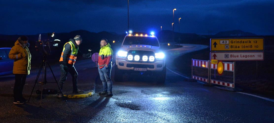
Roadblock at the junction from Reykjanesbraut and the road to Grindavík during TV interview
Monday, November 13, 2023.
First of all: so far no one was seriously injured in Grindavík, but the town (population approx. 3.700) is currently no longer considered habitable.
Residents are only allowed to briefly go to their homes accompanied by the police and rescue workers to pick up their most important valuables and belongings. Besides the residents, all animals have now also been evacuated.
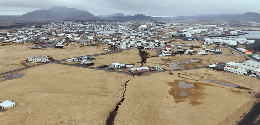
After the severe earthquakes, Grindavík is riddled with massive cracks, making some roads no longer passable.
Friends of ours even provide free housing here at Hvalfjörður for residents from Grindavík.
Despite the entire situation, it's wonderful to see how people stick together here. The future will show how this whole thing will continue.
Although we have access to private photos, I will not show them. I have decided to stop my Reykjanes documentation at this point until further notice - Currently I have no more words for this situation.
Hopefully everything goes well somehow.
All the best to Grindavik's people.
Monday, December 18, 2023.
First of all, it is important to say, that neither Grindavík, nor the geothermal power plant or the Blue Lagoon are currently directly affected by the eruption.
The beginning of the eruption is significantly stronger than the last three eruptions on the Reykjanes Peninsula.
The fissure opens at a quarter past ten at night north-east of Grindavik near Sundhnúkagígar between Hagafell in the south and Stóra-Skógfell in the north with a length of almost 4 km. This is approx. 7 km west of the first eruption site at Fagradalsfjall 2021.
The distance from the southern end of the fissure to Grindavík is about 3 km.
In the meantime, the Blue Lagoon was opened again and repair work was already being carried out in Grindavík.
However, due to the eruption, the lagoon is closed again and all people, who work in Grindavík, are immediately evacuated again. The town itself was not yet inhabited in the meantime.
They are currently concentrating on completing the protective wall around the power plant, as it is impossible to estimate whether further cracks will open in a different location. Grindavík and the Blue Lagoon are also still in danger of being threatened, if the eruption changes locally.
Our friend Silla takes the following photo on Monday night at 11:00 p.m. from her home town Vogar (Distance approx. 10 km to the north) when the eruption just started 45 min. ago.
You can clearly see the red enlightened snowy mountains in front of the eruption's glow. The same mountains are in the background behind the emergency vehicle in the previous picture.
Silla is also the artist who made the wonderful Tree of Live for us. You can find a photo under “OUR STORY”
Thank you for sending us this impressive photo!
Sundhnúkagígar eruption seen from Vogar 45 minutes after it started
Wednesday, December 20, 2023.
The eruption has decreased significantly. The fissure is more or less closed and only one active crater is left.
The lava outflow is now very low and currently no infrastructure is threatened.
Nevertheless the entire Grindavik area, the Blue Lagoon and the power station are still considered to be at high risk. According to the authorities, new fissures could open without any warning in the whole area any time.
Hiking to the eruption site is strongly forbidden. In any case, access to the entire area will remain completely prohibited at least until December 28th.
Scientists absolutely disagree: Is the eruption over? Will new fissures open? Is this just the foreplay to a much more massive eruption?
No matter what happens, it would be great if there was no further damage to the country and its people!
Friday, December 22, 2023.
Unofficially, the eruption is considered to have ended because there is no longer any activity to be seen at the fissure or the craters.
From tomorrow on the residents are allowed to go back to Grindavík for celebrating Christmas and for beginning dayly life again.
Apparently one day after Christmas the closing signs will be taken down officially and everyone will be allowed to enter Grindavík again.
However, as the risk of another eruption in or near Grindavík is still very high, this is all done at the resident's and visitor's own risk. There will be no special rescue workers on site.
In case of immediate danger, an alarm is given and everyone has to escape self organized via one of the three arterial roads.
If all this information from MBL (among others) is really true, I think Grindavík will soon be overrun by tourists!

Monday, January 8, 2024.
Around 30 families celebrated Christmas in Gríndavik and about 25 families were also in town on New Year's Eve. That's about 3.5% of Grindavík's population if you count four to five people per family.
The defensive wall around Svartsengi geothermal power plant and around the Blue Lagoon is almost finished. Work is currently done on the wall north of Grindavík.
Although land uplift is still ongoing massively, the Blue Lagoon reopened last Saturday. You can use there all facilities except the two hotels. However, driving there is only allowed with organized buses and not with your own car.
Everyone is waiting for an eruption again, but of course the location cannot be predicted.
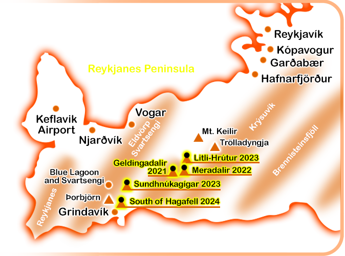
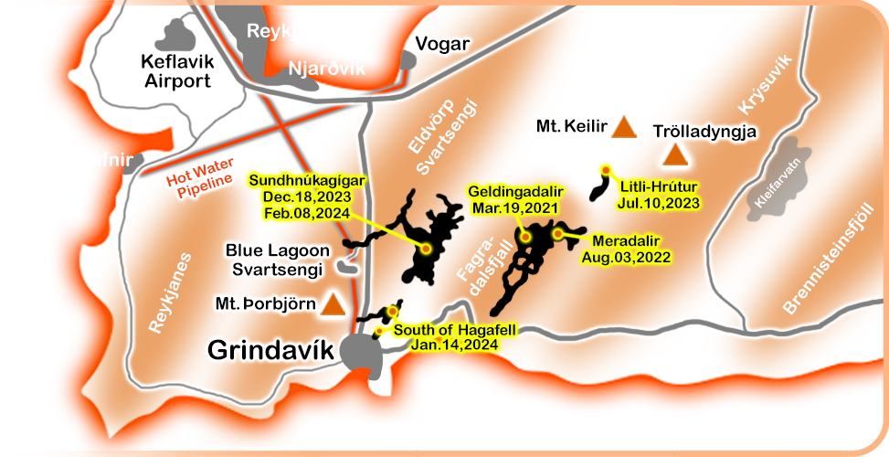
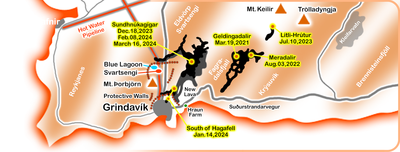
Since I was sitting at home with Corona over New Year's Eve, I had time and created a small overview of volcanoes in Iceland and in particular the activities on the Reykjanes Peninsula.
The whole thing has no claim to completeness, but essentially shows active volcanoes over the last 2000 years.
In addition to the volcanoes themselves, the diagonal volcanic systems are also shown on Reykjanes.
Just a few words about why there are volcanoes in Iceland:
The island is located on the Mid-Atlantic Ridge, a so-called Rift Valley Zone. There the Eurasian continental plate meets the North American plate. Tectonic unrest is commonplace.
In addition, it is believed that the so-called "Icelandic plume" exists underground, which is responsible for the rise of magma and the formation of Iceland.
At this point I won't delve deeper into the topic - if you're interested, you'll find plenty of information on the web. In any case, the conditions are optimal for volcanic activity!
Maybe this more or less simple graphic will help you to better understand what is happening in Iceland.
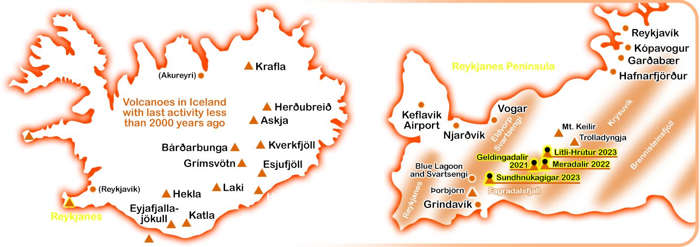
In general, a period of seismic and volcanic unrest is currently predicted for the Reykjanes Peninsula, which will not only be limited to the area around Grindavík.
There are currently the first signs in form of earthquakes that even the volcanic system "Krysuvík" to the east on the peninsula could slowly wake up.
The main volcano in this system is called "Trölladyngja". (Please see again picture to the left.)
Since this system extends to Hafnarfjörður, Garðabær, Kópavogur and the northern city limits of Reykjavík, the geologists are paying close attention to it.
So there is not only "the one volcano" on the peninsula that can erupt. Eruptions are possible unpredictable in many places on Reykjanes.
Because images are nicer to look at than text is, to the right you'll find a few pictures of the Krýsuvík system that I took in summer 2022 but have not published yet.
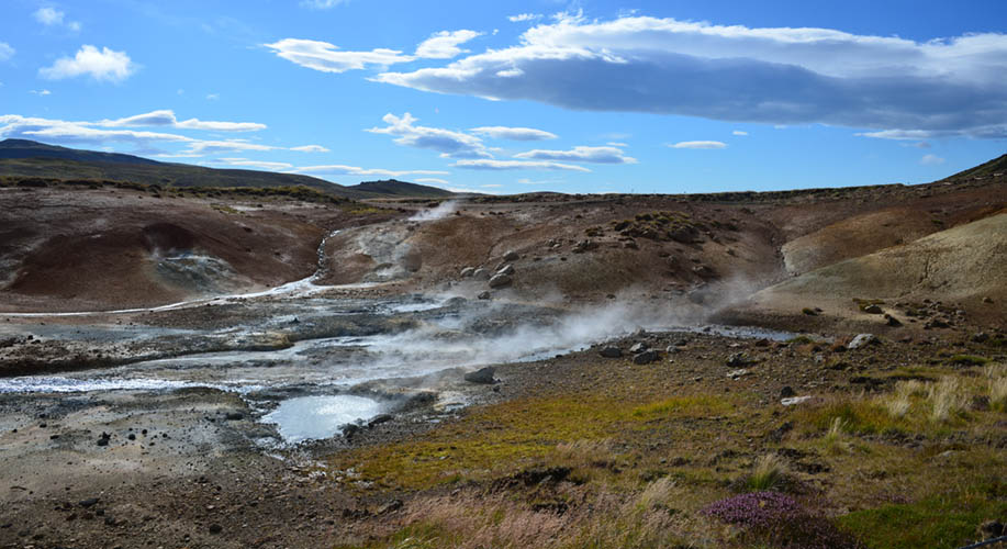
High temperature area "Seltún" in the Krysuvík volcanic system
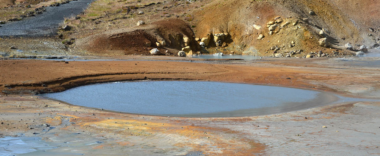
Mainly sulfur gases emerge from these 100°C hot springs (Krysuvík)
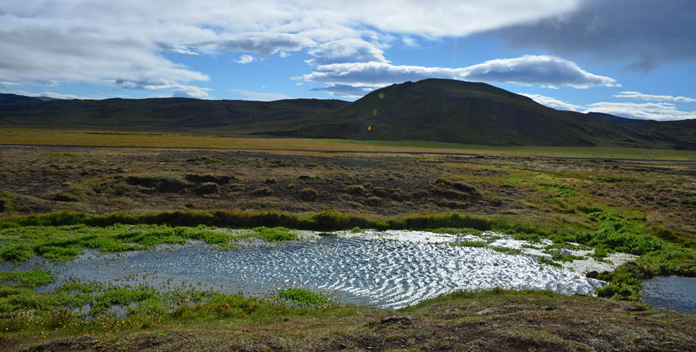
Skátalaug Hotpot (Krysuvík)
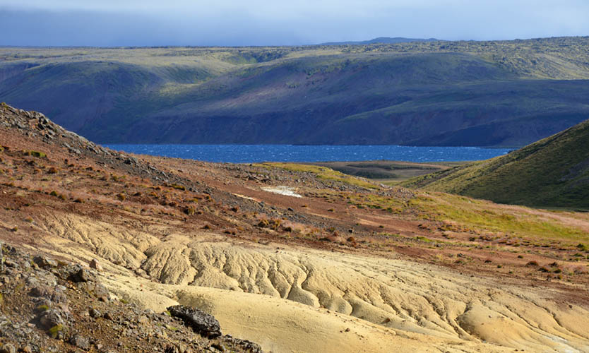
View from Seltún to Kleifarvatn (Krysuvík)
Sunday, January 14, 2024.
This time things do not look good at all.
The fifth eruption begins at 7:57 a.m. south of Mount Hagafell. The eruption was once again preceded by a swarm of earthquakes up to magnitude 3.5.
Lava is now about 700 m north of Grindavík and directly in front of a company outside the town.
The eruption fissure actually runs through the protective wall, that is currently under construction. On live cameras you can see that construction equipment is being removed as quickly as possible.
The only remaining hope is now a soon end of the eruption and that lava flow will stop.
Following the photo on the right you'll find updates and the map with the location of the 5th eruption "South of Hagafell 2024". The dangerous proximity to Grindavík is clearly visible in both pictures.
In this case, we have exceptionally acquired the image rights from the "Icelandic Department of Civil Protection and Emergyncy Management" in order to show the seriousness of the situation with this aerial view.
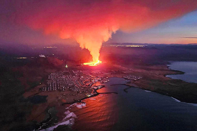
Photo/License: Icelandic Department of Civil Protection and Emergency Management/Getty
Now the worst case scenario happens: half a day after the fissure south of Hagafell opened, now a second fissure opens directly at the city limit of Grindavík. Lava has almost reached the first house.
The connecting road to the Blue Lagoon is meanwhile also flooded with lava that comes from the first fissure.
The city is completely evacuated. To be honest, only a miracle could save Grindavík now.
The Icelandic Red Cross has set up a link where you can donate directly to projects around Grindavík:
Click here for donating to Grindavík's people via Red Cross.
In the afternoon, the first houses in the northern part of Grindavík called "Efrahóp" are set on fire by lava from the second fissure.
The hot and cold water pipes to the town are also destroyed by lava. The remaining city has no longer any heating or water supply.
Tuesday, January 16, 2024.
The icelandic professor Þorvaldur Þórðarson declared the 5th eruption as over.
Three houses have been destroyed by fire and many additional cracks have appeared in the city's ground.
The water and power supply could be partially restored. Nevertheless, the city will be uninhabitable for a long time.
No one was killed caused by the eruption.
Nobody can predict how the ground below Grindavík will behave and whether there will be further eruptions or cracks.
The government is already working on creating housing for Grindavík's residents in other parts of Iceland.
The authorities are also currently thinking about two scenarios: whether to abandon the city or make it habitable again.
Unfortunately, the ground is already lifting again and it looks as if the next eruption is maybe coming soon.
I do not document the damage and the threatened destruction of the city.
For now, I will remember Grindavík as I have known it since the year 2000.
In case of a new eruption I may create overview graphics again to visualize the position. Pictures will only be given again when we have our own photos or such, that we are legally allowed to use. I do not copy images from the internet.
To the people of Grindavík:
Please stay strong and don't lose hope.

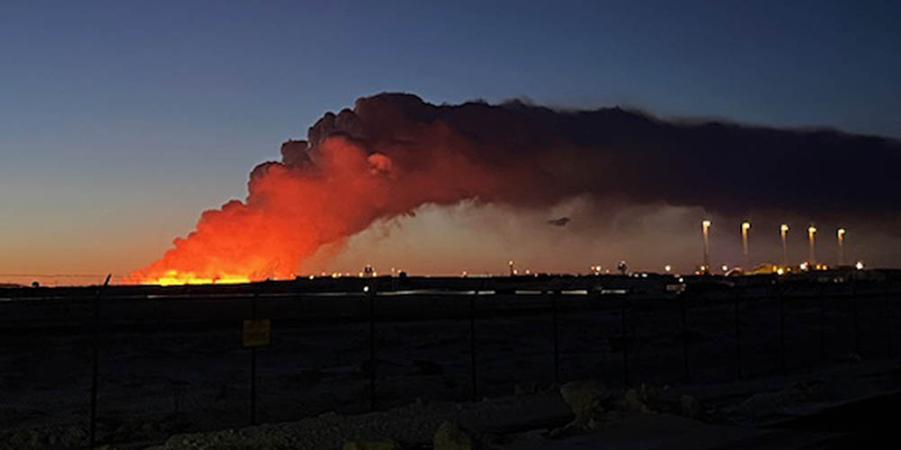
Thursday, February 8, 2024.
Today at 6:00 a.m. the sixth eruption starts at the same location as the fourth eruption on December 18, 2023, between Sundhnúk and Stóra-Skógfell.
By around 7:00 a.m. the fissure is about 3 km long. According to the Coast Guard, the lava is flowing mostly in western direction.
Grindavík is currently not in danger. Lave flows in the opposite direction (north-west).
Although the cracks (without lava outflow) through the town of Grindavík have become more frequent and larger in recent weeks, residents have been allowed to go back to their houses for six hours to pick up additional property.
The place is still considered uninhabitable, but residents and business owners are now starting to sue in court. In their opinion, it is anchored in their fundamental rights, that they are allowed to access their properties without restriction even during this dangerous situation.
However, Grindavík is still not abandoned, because the electricity and hot water supply is maintained with great effort to avoid further damage.
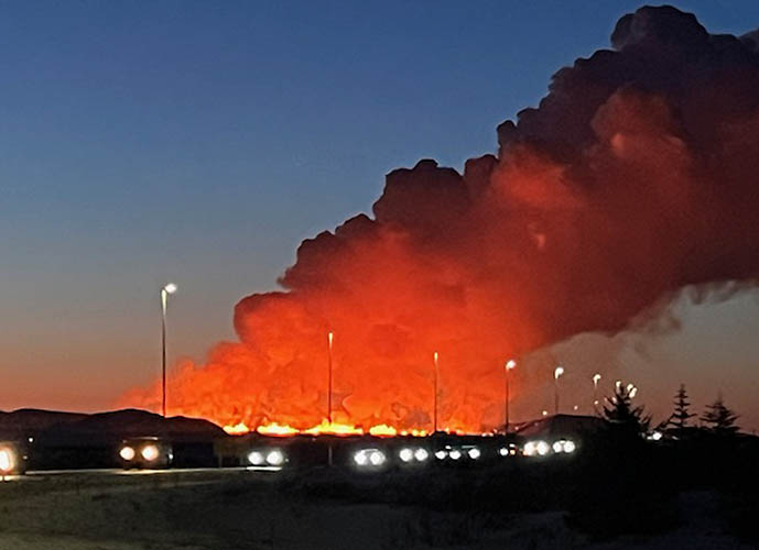
Our friend Dr. Robert de Lange (from Germany) happened to be driving from Hvalfjörður to the Keflavík airport right at the start of the eruption.
Along the way, he takes extremely impressive photos of the first minutes of the eruption from various perspectives out of his car.
In addition to the photos, Robert also gives us the positions and times for each photo.
So please see the descriptions below the photos for the position.
Many thank's to Robert for sending us these spectacular pictures!!!
06:34 a.m. - Junction Ringroad No. 1 and Hvalfjarðarvegur (southern tunnel exit)
07:15 am - Seen from Hafnarfjörður
Perspective from east of Vogar (Reykjanesbraut)
Seen from junction Reykjanesbraut and Grindavíkurvegur
Perspective from near the Keflavík Airport
Now the length of the eruption fissure is clearly visible
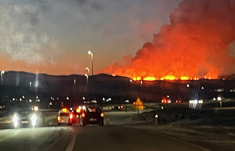
...an impressive background for the morning traffic!
At noon:
Lava is still spreading westward at relatively high speed towards Svartsengi Power Plant and the Blue Lagoon.
The road from Vogar/Njarðvík to Grindavík is now destroyed at the junction to the Blue Lagoon and the lava flowes close to the protective wall in front of the power plant and the lagoon.
The hot water pipe from Svartsengi to the towns on the Reykjanes Peninsula is also interrupted, that means most of the houses on the entire peninsula can currently no longer be heated.
As a precaution, a 500 meter long replacement line has already been built underground. Work already started to connect this replacement line to ensure the hot water supply for the peninsula again, as far as the Svartsengi Power Plant is not directly affected by lava. Reactivating the hot water supply should take aboud three days.
Although the intensity of the eruption appears to be subsiding, the situation for the entire peninsula is extremely critical.
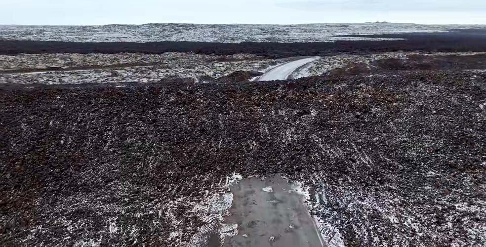
Please see map with all new lava fields since 2021.
In the evening:
The activity of the eruption is continuing to decline significantly.
Compared to the 3 km long expansion today in the morning, now only two active craters are visible on livecams at the fissure.
The new lava field north of the power plant and the Blue Lagoon is still glowing but doesn't seem to be expanding anymore.
Good news: it is possible that the peninsula's hot water supply can be restored until tomorrow evening.
Important: For both locals and tourists it is absolutely forbidden to approach the site of the eruption! The entire situation is still unpredictable and extremely dangerous.
Saturday, February 10, 2024.
The eruption is officially declared as over. Rebuilding the hot water supply is not yet complete because the backup line was unfortunately damaged by lava, too.

Monday, March 4th, 2024.
Everyone assumes that there will be a new eruption during the day, as there is another dyke intrusion after strong earthquakes.
Magma rises from the chamber below Svartsengi to higher levels in the underground probably towards Sundhnúkagigar again.
Even the Blue Lagoon is evacuated within 40 minutes.
Although the critical amount of 9 to 13 million cubic meters of magma has been reached again under Svartsengi, the dyke intrusion stopps at only 1.3 million cubic meters of magma.
Activity suddenly subsides and there is no eruption.
Saturday, March 16, 2024.
The 7th eruption begins at 8:23 p.m. local Icelandic time again at the Sundhnúka crater row between Hagafell and Stóra-Skógfell, slightly closer to Stóra-Skógfell, almost at the same location as on February 8th.
Both Grindavík and the Blue Lagoon are being evacuated. There are 700-800 guests in the Blue Lagoon at the start of the eruption.
At the moment, according to volcanologists, the lava seems to be flowing past Hagafell towards Grindavík.
Sunday, March 17, 2024.
The current eruption is the strongest at the Sundhnúkur location with lava flow to the west and south-east.
The lava takes a slightly new direction and is now only 200 meters away from Suðurstrandarvegur on the south coast. It is flowing along the protective wall east of Grindavík.
A smaller part of the lava flows northwest and is already near Svartsengi, the Blue Lagoon and 200 meters away from the rebuilt hot water pipeline.
Tuesday, March 26, 2024.
Unlike the last three eruptions, this eruption lasts a surprisingly long time.
There is also no further land uplift at Svartsengi, so it can be assumed that the channel from the magma chamber to the craters remains open.
Three craters are still active and one has already grown so high that you can even see it from Reykjanesbraut near Vogar spitting lava in the air!
Unfortunately, the lava is still flowing towards Grindavík and a lake of lava is currently damming up at the defensive walls.
The walls urgently need to be built higher otherwise the lava threatens to spill over and flow through eastern Grindavík and to the harbor.
However, there is no longer any lava flow towards Svartsengi Power Plant and the Blue Lagoon.
It is always reported that land is rising at Svartsengi and Blue Lagoon area, but the eruptions occur unpredictable in other locations.
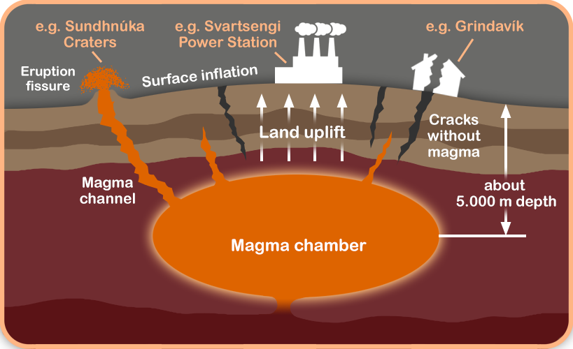
The reason why is explained to the right in a new graphic with a section through the earth's crust and mantle:
The growing magma chamber exerts pressure and causes a land uplift.
The resulting tension causes cracks on the surface, but also cracks that extend deep into the magma chamber.
Due to different rock densities and formations, it is impossible to predict where a fissure opens up, that carries magma.
The other fissures are not deep enough to bring magma to the surface but wide enough to destroy roads and houses as it happens in Grindavík.
That's why you can't predict whether an eruption will occur right at the center of the land uplift or somewhere else in the area around.
There is a very unique reporter from northern Iceland, who basicly does the same as "HUH.IS" does: He is documenting Iceland since years.
Please let me introduce Gylfi from North Iceland and his youtube channel "JUST ICELANDIC".
Gylfi is considering himself as a "professional Icelander" using his local knowledge bringing Iceland to the viewers.
He broadcasts volcano news mixed with Icelandic history, culture, documentaries and travel information.
You can rely 100% on his information and it is a great pleasure to listen to his "english narration with rough north icelandic accent."
Since it has become almost impossible for people without an Icelandic press pass to document the eruptions on the Reykjanes Peninsula, I am very happy that I can hand it over to Gylfi at this point.
I fully understand the authorities and their decision to close the whole area for the public, because the current situation is really dangerous. Cracks can open almost everywhere, locations of new eruptions are not predictable and volcanic gases or smoke from the mossfires affect one's health.
Of course I will NOT STOPP my work on HUH.IS!
I will do more better plan-able projects like "SHIPWRECKS and more" or similar. If I happen to see an active eruption in Iceland again, I will of course take new photos, too.
In the future there will probably be common projects with JUST ICELANDIC and HUH.IS together - We are really looking forward!
To the right you will find a lot of excellent pictures taken by Gylfi. Following the pictures you'll find the direct link to his channel.
Please subscribe and support Gylfi with his work on JUST ICELANDIC!
Therefore, at this point I am closing my Reykjanes documentation until further notice and I am passing the ball to Gylfi...
Blue Lagoon and Svartsengi Power Station surrounded by new defensive walls a few days before lava overflows the access road
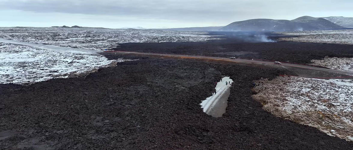
A new temporary road is being built over the fresh and partly still hot lava
Tourists with a ticket to the Blue Lagoon are allowed to visit the area - some of them walk around irresponsibly on the fresh lava
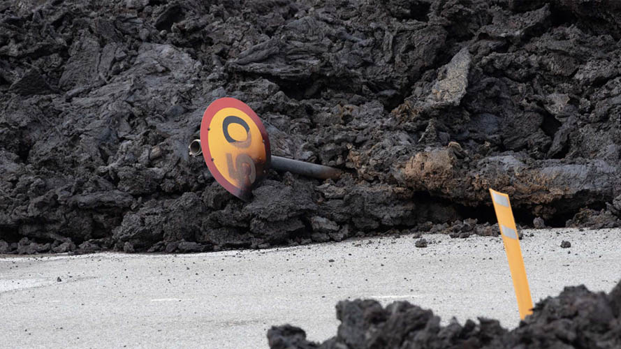
Lava is melting a traffic sign near the Blue Lagoon junction
Defensive wall crossing the street with fresh lava in the background

The defensive wall can successfully protect the company building north of Grindavík from being destroyed by lava
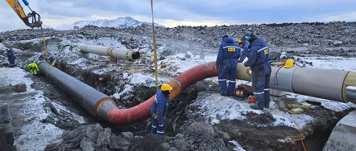
Plumbers connect a new prefabricated hot water line after the existing one was destroyed by lava
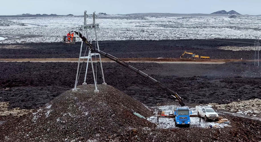
Electricity poles are moved to artificial hills to allow lava flowing around them
Lava field from the fifth eruption on the city limits of Grindavík, where three houses were destroyed
One of many cracks that run through Grindavík (We show no recognizable details of destroyed private property)
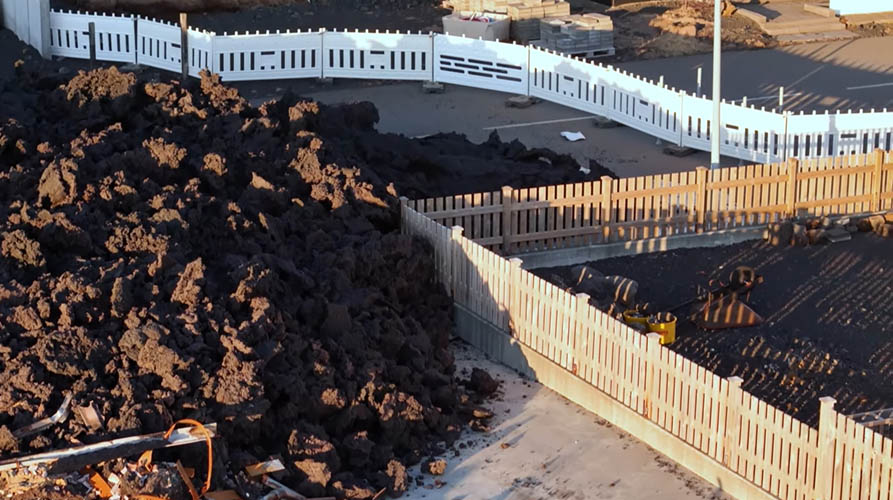
The "miracle" of the non-burning-wooden-fence...
Lava hits the fence but it does not catch fire...
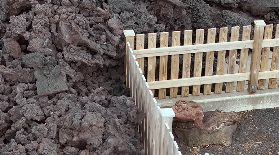
The fence doesn't even change its color!
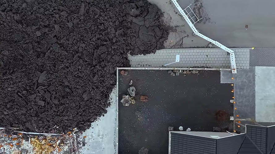
Lava flows over a sidewalk
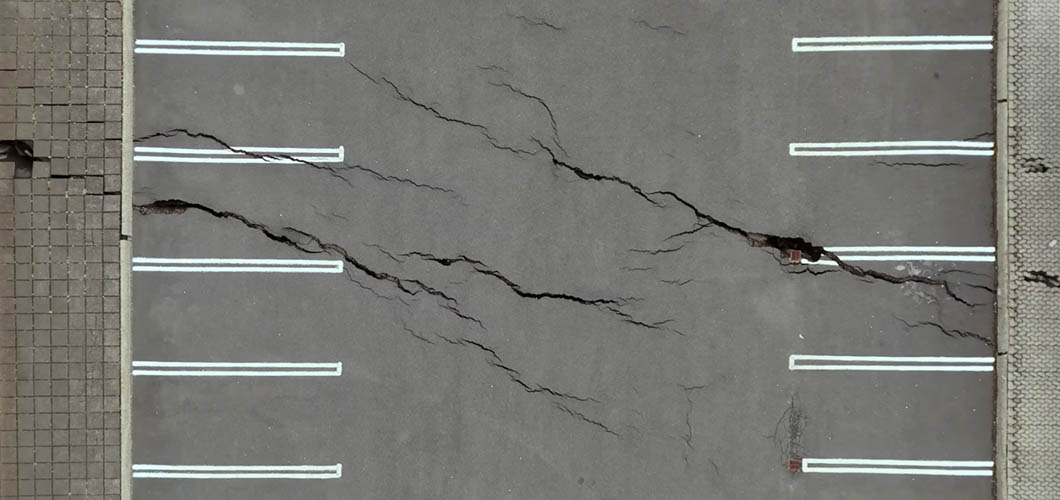
Cracks in the tar surface on a parking lot
Current eruption site, lava fields, Svartsengi, Blue Lagoon, Grindavík in the background and the huge cloud carrying volcanic gases
Great night view, but volcanic gases can threaten people at the Blue Lagoon - that's why it still remains closed
For further information about the Reykjanes eruptions and much more, please click "JUST ICELANDIC" to the right.
This documentation ends here until further notice. New photo series on other topics will of course come again in the future.
All the best for Grindavík's people, the employees of the Blue Lagoon and the Svartsengi power plant as well as everyone on the entire Reykjanes peninsula.
April 3rd, 2024